


Coastal ecosystems support fisheries, tourism, shoreline stability, and water quality. Yet these fragile environments face constant pressure from coastal surveying to development, vessel traffic, storms, and changing water conditions. Effective coastal surveying plays a key role in reducing harm to underwater habitats by guiding planning, construction, and conservation actions with accurate data. A well-planned seagrass survey in the early stage of any marine project allows experts to map sensitive areas before disturbance occurs. Using modern bathymetric survey services and integrated coastal survey solutions, marine professionals can locate vital habitats, monitor changes over time, and help agencies make informed decisions that safeguard seagrass meadows and coral reefs.
This article explains how survey methods support habitat protection, why data accuracy matters, and how scientific assessments help maintain healthy marine ecosystems.
Why Seagrass And Coral Habitats Matter
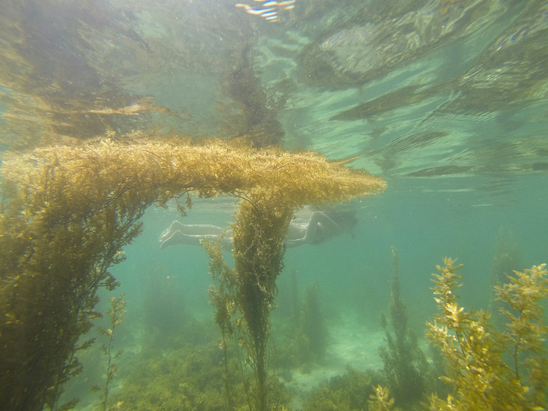
Seagrass meadows act as underwater forests. They provide nursery grounds for fish, feeding areas for turtles and manatees, and help stabilize sediments. These meadows also capture carbon and improve water clarity by trapping particles in the water column. Coral reefs serve as natural breakwaters that reduce wave energy, protect shorelines from erosion, and support rich marine life. Together, seagrass beds and coral reefs form a connected habitat network where the health of one supports the other.
Damage to either system can trigger a chain reaction. Sediment stirred by dredging can smother corals. Anchor drops can tear seagrass roots. Poor water circulation can reduce the light needed for photosynthesis. These risks make careful planning essential before any activity occurs near the coast.
The Role Of Coastal Surveying In Habitat Protection
Coastal surveying collects precise information about seabed shape, water depth, sediment type, and biological presence. This information becomes the foundation for environmental planning. Marine survey data helps identify where sensitive habitats exist and where activity should be limited or redesigned.
Accurate seabed maps help engineers plan navigation channels without cutting through seagrass beds. Coastal construction teams use survey results to place marine structures away from coral outcrops. Environmental consultants use time series surveys to track habitat recovery after restoration efforts.
Without reliable survey data, decisions rely on assumptions. That increases the chance of accidental damage and costly project delays. With proper surveying, protection measures can be built into project design from the start.
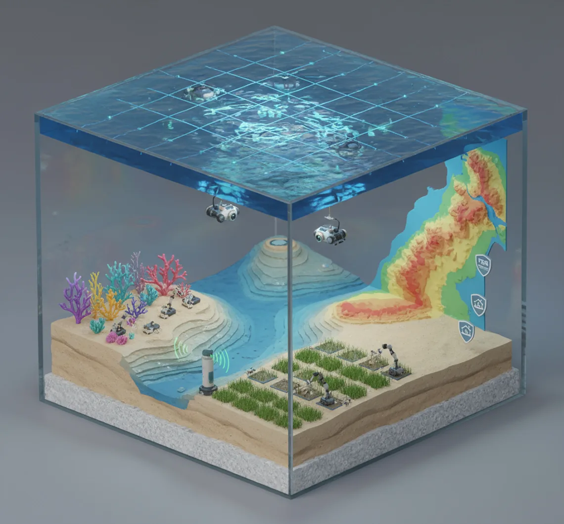
Coastal Surveying Methods Used In Sensitive Marine Areas
Several marine survey techniques support habitat protection. Each method offers specific insight into underwater conditions.
Bathymetric Mapping
Bathymetric mapping uses sonar to measure water depth and seabed contours. High-resolution mapping shows slopes, channels, and reef formations. This allows planners to avoid excavation near corals and limit dredging in vulnerable zones. It also helps determine natural water flow paths so sediment movement can be predicted and controlled.
Side Scan Imaging
Side scan sonar produces detailed images of the seabed surface. It can reveal seagrass patches, coral heads, rocky substrates, and debris. These images help biologists confirm habitat boundaries and guide dive inspections to verify findings.
Sub Bottom Profiling
This method looks beneath the seabed surface to understand sediment layers. It helps determine where construction may cause sediment release that could drift toward reefs or seagrass areas. Knowing sediment composition also supports erosion control planning.
Ground Truthing And Dive Surveys
Remote sensing data is often paired with diver or drone observations. Visual confirmation ensures accurate habitat classification. Divers record species presence, density, and health indicators that technology alone cannot fully capture.
Water Quality Monitoring
Survey programs often include water quality and turbidity monitoring, salinity, and temperature measurements. These factors influence seagrass growth and coral health. Continuous monitoring alerts project teams when conditions approach harmful levels, so activity can pause if needed.
How Survey Data Guides Project Planning
Survey results directly shape project decisions. For example, marina expansions can be redesigned to shift dock placement away from dense seagrass. Pipeline routes can be adjusted to avoid coral clusters. Shoreline stabilization projects can use survey data to select materials that reduce sediment disturbance.
In many regions, environmental agencies require survey documentation before permits are granted. Detailed habitat maps and impact assessments prove that protective steps are included in project plans. This reduces approval delays and builds trust with regulators and local communities.
Survey data also support mitigation strategies. If limited habitat disturbance is unavoidable, restoration plans can be developed based on accurate baseline measurements. That ensures restoration targets match original habitat conditions.
Monitoring Changes Over Time
Protection does not end once construction is complete. Long-term survey programs track habitat health and detect early signs of stress. Repeat mapping can reveal seagrass thinning, coral bleaching zones, or sediment buildup. When issues are identified early, corrective action can begin before serious damage spreads.
Monitoring also measures the success of restoration projects. Replanted seagrass areas can be surveyed to confirm growth progress. Artificial reef installations can be tracked to observe coral recruitment. This feedback improves future project design and conservation methods.
Reducing Human Impact Through Smart Planning
Many habitat threats come from everyday activities such as boating, anchoring, and shoreline modification. Survey data support the creation of navigation channels and mooring zones that keep vessel activity away from sensitive seabeds. It also guides the placement of signage and protected area boundaries.
Tourism operators benefit from mapped reef zones that allow snorkeling and diving without anchor damage. Coastal property owners gain guidance on seawall placement that avoids disrupting sediment flow that nourishes seagrass beds.
By providing clear spatial information, surveying turns conservation rules into practical site-specific guidance.
Supporting Scientific Research And Policy
Large-scale habitat surveys contribute to regional and national ecosystem assessments. Combined data from multiple survey projects builds a clearer picture of habitat trends across coastlines. Scientists use this information to study climate effects, storm recovery patterns, and species migration.
Policy makers rely on survey findings to define protected zones, update environmental regulations, and prioritize restoration funding. Without consistent data collection, these decisions would lack accuracy.
Benefits For Coastal Communities
Healthy seagrass and coral habitats support fisheries, tourism income, and shoreline protection. Survey-driven planning helps sustain these benefits. When habitats thrive, fish stocks remain stable, beaches erode less, and water stays clearer. This directly supports local livelihoods and long-term shoreline stability. It also connects with broader efforts discussed in our article on how coastal engineering contributes to resilient coastal communities.
Survey-guided development also reduces costly legal disputes and project redesigns caused by unexpected environmental impacts. Informed planning saves time and investment while protecting natural resources.
Best Practices For Habitat Focused Survey Programs
Successful habitat protection surveys follow clear steps:
- Early surveys before the project design begins
- Use of multiple survey methods for full seabed understanding
- Independent environmental review of findings
- Stakeholder communication, including local communities
- Continuous monitoring during and after project completion
- Adaptive management when survey results show a change
These steps create a strong framework for balancing development needs with ecosystem care.
Future Direction Of Marine Habitat Surveying
Advances in autonomous underwater vehicles, satellite imagery, and artificial intelligence are improving survey speed and detail. These tools make it easier to map large areas frequently and at a lower cost. As technology improves, habitat protection will become more proactive rather than reactive.
Integration of survey databases across agencies and research groups will further improve planning accuracy. Shared data means fewer gaps in habitat knowledge and stronger regional protection strategies.
Conclusion
Seagrass meadows and coral reefs form the backbone of coastal ecosystems. Their protection depends on knowing where they are, how they change, and how human activity affects them. Coastal surveying provides that knowledge. Through precise mapping, careful monitoring, and science-based planning, marine survey programs help ensure marine development proceeds responsibly.
By guiding project design, supporting environmental compliance, and strengthening conservation strategies, modern survey practices serve as a bridge between progress and preservation. When accurate data leads decision-making, underwater habitats gain a stronger chance to survive and flourish for future generations.